Hydrological events of interest during spring 2020:
- An ice jam causing minor flooding was reported on the Nordenskiold River at Carmacks on April 22-23. Ice jams were also detected in other rivers of comparable size in central Yukon, including the Sixtymile and Fortymile.
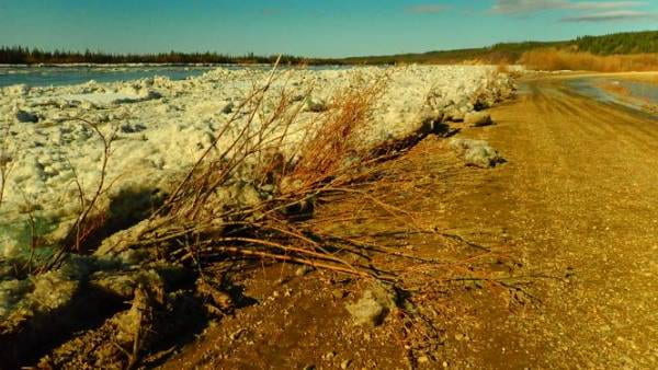
- Ice-induced water levels in the Ch’oodeenjìk (Porcupine River) approached flooding threshold in Old Crow on May 12, but fortunately, the ice run did not stop at or downstream of the community (see Photo).
- Ice jamming was also detected and reported in Alaska as well as in some NWT rivers, including the Liard River at Fort Liard.
- Considering the significant snowpack, freshet (spring snowmelt) flows remained reasonable in most large river systems of Yukon, and flooding mostly affected small creeks (e.g., Hunker Creek).
Highlights of a wet 2020 summer:
- The second highest flow on record (since 1966) in the Tr’ondëk (Klondike River) occurred on June 23 (almost 700 m3/s). This runoff event was caused by a combination of intense rain, residual high-altitude snowmelt, and probably saturated ground. It was preceded in May by a dynamic river ice breakup event that also caused minor flooding.
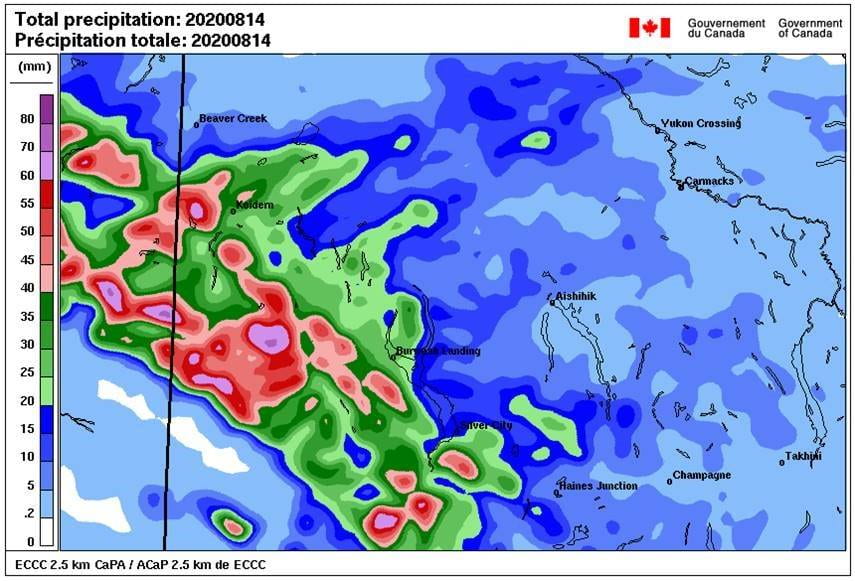
- The highest flow since 1986 occurred in the ʼAt’aayaat Chù’ (White River) on August 14 (almost 1500 m3/s). The peaky runoff wave, apparently caused by intense rain in a sub-basin, reached Dawson City 48 hours later, generating a sudden 0.7 m water level rise in the Tágà Shäw (Yukon River in Southern Tutchone). Woody debris were observed at the Ferry Crossing. [In comparison, the Dań Zhùr Chù’ (Donjek River) glacial lake release that took place on July 13, 2019, only caused a 0.3 m water level rise at Dawson two days later.] This map, prepared by Environment Canada, presents the approximate 24-h precipitation for August 14 in the Kluane region.
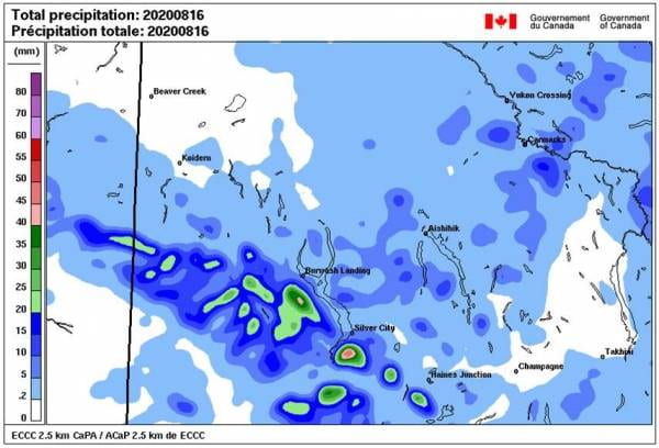
- Mud slides in steep creeks caused problems along the Alaska Highway at the southern tip of Lhù’ààn Mân’ (Kluane Lake) on August 17. Despite all this rain, the water level in the Lake remained more than 1 m below the pre-2016 (’A’ą̈y Chù’ [Slims River] piracy) average summer level. The following map, also prepared by Environment Canada, shows an intense precipitation even just south of Silver City on August 16.
Into Winter 2020-2021:
- River ice formation is taking place along the Tagé Cho (Yukon River in Northern Tutchone) at Carmacks as these lines are being written. This can generate a water level rise of almost 3 m in less than a day. It is possible that the highest water level of the year in Carmacks is often associated with the river ice formation period. Is this a result of climate change, or has it always been like that? There are stories that recent years’ data cannot tell.
- Relatively high flows have been reported for the Yukon River, Stewart River, Pelly River, Liard River and Peel River before freeze-up. This condition is believed to yeild thicker ice covers during the first half of winter, to reduce the probability of ice jams in the spring, but also to generate more severe ice jams when they occur.