The Yukon University Research Centre has developed a hydrodynamic model of the Klondike River. How does this work and how is this useful?

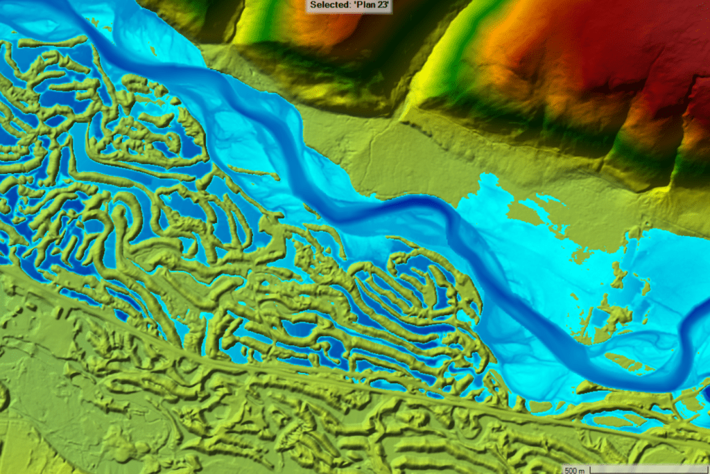
Figure 1. Aerial view of a portion of the Klondike River located about 8 km upstream of Dawson (further to the left). The blue scale of increasing darkness simulates the water depth (0 to 5 m) at high flow whereas the khaki (low) to red (high) scale represents the emerged terrain topography. The Klondike Highway is the continuous khaki line extending from right to left south (below) the river, within the mining tailings.
Description of the river model:
This model is developed using a free software called HEC RAS (Hydrologic Engineering Center’s River Analysis System), created and improved over the years by the United States Army Corps of Engineers. Physical equations in HEC RAS simulate the way water flows on a solid surface, either the river bed or the floodplain. The software is relatively simple to operate and widely used by river scientists and engineers to estimate channel parameters such as water depth, water velocity and lateral flood extents. HEC RAS also has the capacity to simulate dynamic flood waves as well as water levels in the presence of a surface ice cover or a static (immobile) ice jam.
First, the model needs to be built using terrain information. In the case of the Klondike River model, this information includes a digital elevation model (high-density topographic information) prepared by the Government of Yukon and approximate bathymetric information (underwater topography). Then, the model needs to be calibrated using known water levels and flows. This data was obtained from Water Survey of Canada historical records at station 09EA003.
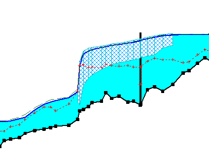
If the model is to be used to simulate the impact of ice jams – a dominant flooding process along the Klondike River (refer to a previous blog post from February 2021) – it is also essential to perform another calibration using known water levels and reasonable discharge estimates during an historical ice jam. In our case, the model was calibrated using information from the 1986 and 2021 ice jams; both jams formed downstream of the Klondike Highway bridge. Figure 2 presents an example of the simulated river profile affected by an ice jam that obstructs the flow, therefore water levels under and upstream of the jam (on the middle right) are higher compared to what they are downstream of the jam (on the left).

Figure 2. Profile of the Klondike River channel in the presence of a simulated ice jam that formed downstream of (and extended across) the Klondike Highway bridge (vertical black line). Flow is towards the left, the channel bed is the dotted black line, water is blue, and the ice jam is hatched.
Use of the model:
The Klondike River is probably one of the most challenging river environments to simulate with this type of model, given the shallow water conditions, steepness of the valley, multiple secondary channels, minining legacy, and complex river ice processes. The first version of the model is currently being used for a preliminary assessment of maximum flood elevations. It will also be used for teaching and training purposes at Yukon University and will continue to be improved over time.
In the future, the HEC RAS model of the Klondike River could be used for different purposes:
- Determining water levels in the channel and on the floodplain for any (realistic) discharge and ice conditions
- Simulating the impact of climate change, through altered flows and ice conditions, on water levels in the Klondike River valley
- Simulating the impact of hydraulic structures such as bridge abutments or dikes on water levels
- Contributing to the design of safe inchannel and floodplain infrastructure
- Evaluating the probability or the frequency of flooding or failure for different infrastructure and buildings
- Estimating water velocities at various locations to provide information about fish habitat or paddling conditions
- Forecasting floods (water levels)
Limitations of the model:
A hydrodynamic model, like any model, attempts to simulate reality. However, models are rarely perfect and they should be primarily considered as learning or judgment guiding tools. Residual errors (for example, a +/- 15 cm imprecision in water levels) are common.
Any form of design (e.g., bridge structure elevation, dike height, flood maps) cannot solely rely on raw model outputs, more so if model results are to be used in a context where the safety of the public or the integrity of the natural environment are at sake. Experienced practitioners, just like artists, need to finish their product and evaluate if the results are satisfactory. In turn, similarly to a painting, a recipe, or a melody, a hydrodynamic model should never be overdone (over calibrated), especially in a context where the river channel is mobile: islands and gravel bars gradually shift every year, and this has an impact on water levels.